Wednesday, April 24, 2024

The Hurricane Season From Hell. Blockbuster. Historic...

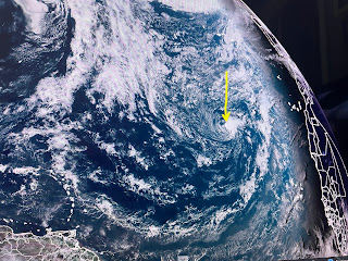
If you have been in a cave & missed all the main preseason Hurricane predictions, go back into hibernation.  Most of us have heard the awful numbers (25-30+ named storms) being throw out there based on record warm waters and the oncoming La Nina.  I have not seen anybody come out with a below normal/average prediction.  So how could we reach those high number you ask?  Try naming every little swirl out over the oceans despite the fact it'll impact no one.  Case in point, NHC's watching an area off of Africa. Why?  Can you see it?  Look at the yellow arrow.


While NHC was mentioning this weak feature, there was another story about the huge African dust cloud over Greece.


There are no signs yet of that dust cloud moving out over the eastern Tropical Atlantic, but I did read one paper pointing out that several factors might limit the number of named storms this season and one reason is increased dust.  To me, the phase of the Madden- Julian Oscillation (MJO) and the position of the Bermuda high will factor into the 2024 season as much as warm water temps.  We want the enhanced (rising air) phase to happen outside of August to early October when we typically see our strongest storms.   Whatever, it's silly to get nervous/concerned while we're still in April!


With the upper pattern mainly west to east with no major dips, the weather should remain quiet here through the weekend.  Farther to the north, SPC is indicating the potential for strong storms tomorrow into Friday.  The top is for Thursday with a level 3 risk from Texas into Kansas. that area weakens for Friday.


There is a stream of 60-70 degree dew points surging northward over Texas with our DPs jumping from the 30s to near 60.  That trend will continue into next week.


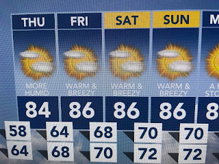
Cloud cover has increased, but radar shows very little rain falling anywhere.  It does feel different outside as highs top 80.


Since no fronts are coming in the short term, highs will stay above normal into next week..  There is a slight chance for some stray showers next week, but the first week of Jazz Fest & the Zurich Golf tourney will enjoy great weather IF you have a hat & use sunscreen.  Finally...


In the history of WVUE-TV, no General Manager had a greater impact than Joe Cook.  Joe came to Ch.8 from Ch. 10 (WALA-TV) in Mobile in 2000 at a time when we were a poor # 3 or 4 in the local news ratings.  During his time here, he elevated FOX 8 to the top in local news numbers before retiring.  There is a song in the musical Damn Yankees that says, "and now your Joe has to go".  Joe died on Monday at age 72.  Though he was my "boss", he always treated me & my wife as family.  Good bye old friend, my old friend.  Prayers go out to his wife Becky & his children.  Stay tuned!

Monday, April 22, 2024

Mississippi River Nearing 12 Feet, All Quiet On The Southern Front

It was days like this, where nothing is going on, that challenged my creativity in trying to keep viewers watching.  Oh sure, I could take the easy road and point out the obvious (sunny skies, low humidity & comfy temperatures, Duh!), but I liked to find unusual stuff just to keep folks from being bored.  For instance, just because it hasn't rained much here in the past 10 days, not so farther to our north.  A high river crest has been coming down the Mississippi and the river is likely to stay high for awhile.  Let's discuss.  It sure doesn't take a rocket scientist looking at satellite views to see why it's called "The Muddy Mississippi."  North winds have cleared out Lake P for the North shore, but the South Shore is all stirred up.  


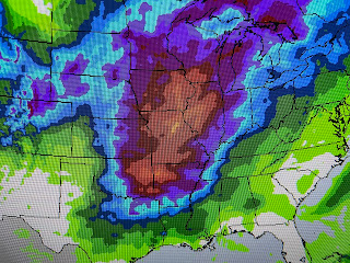
The plume of muddy waters is making for difficult fishing conditions from Port Sulphur southward. Note how the River forecast is only for a slow fall for the next 7 days.  Why?  Look at the 7 day rainfall totals.


The reds & oranges indicate 3-5"+ totals and all that water has to drain our way.  No need to worry since our levees protect us is 20 feet and the river levels will be way less than that.  So what else is there to talk about?  Not much.


As we transition into summer, the jet stream weakens and shifts northward.  The weak disturbance moving across south Texas will stay well south of us as a large, comfy cool surface high brings us the good feel air.


Dew points remain in the 30s & 40s, but return flow should bring back the muggies by Wednesday PM. A sure sign that summer is coming is seeing near 100 degree heat in Phoenix.


We'll start to feel Summer-like later this week, but mid to upper 80s are tolerable.  It's the dreaded 90s that we have to endure for the coming months.  Finally,


My oldest son & his wife(Rob & Sarah) moved from Colorado after 20+ years to live in Albuquerque.  Was it to leave the mountain views?  Nope, look at this view last night from his new home.  They just wanted to go to a more friendly climate where it doesn't snow into April and the sun shines 300+ days a year.  Plus there is near zero humidity.  Gotta love that!  Stay tuned!